The place · History

The harbour of the Argonauts and the castle made of wood

Before Xylokastro, this was Aristonautai. Pausanias writes that the harbour took its name from the Argonauts, who moored on this coast with the Argo. The town's present name came much later, from a castle built of wood.

The myth on the ground

One harbour, two names

On the spot where the pine forest of Pefkias now meets the water, ancient geographers placed a harbour called Aristonautai. The town's present name is far more recent, and it comes from a fort raised on the same shore centuries later.

Behind the town rises Kyllene, today's Ziria, a mountain that mythology holds to be the birthplace of the god Hermes. And a few kilometres further west, inland, lie the ruins of Pellene, the easternmost of the twelve cities of the Achaean League, whose seaport was Aristonautai.

Three threads

The harbour, the city and the god

01

Pausanias 2.12.2 & 7.26.14

The harbour of the Argonauts

The traveller Pausanias, writing in the 2nd century AD, mentions the harbour Aristonautai twice and explains its name: it was given because the Argonauts moored there on their voyage. Their ship, the Argo, was built from Pelion pine, an all-wooden vessel that tied up on this coast.

Centuries later a castle of wood was raised on the same shore. The town's present name came from it, long after the ancient harbour had stopped working.

Legend names the Titan Pallas as its first founder. The temple of Poseidon, which the Aristonautai kept in their care, stood where the old railway station of Xylokastro was later built.
02

Ruins near present-day Pellene / Zougra

Ancient Pellene

The harbour served Pellene, the easternmost of the twelve cities of the Achaean League. The city lay sixty stadia from the sea, built on a hill that a steep peak split in two, giving it a natural acropolis. Ancient sources place the harbour one hundred and twenty stadia from Aigeira.

Pellene was famous for its woollen cloaks. They were heavy capes, sought after enough to be given as prizes to the victors of the Theoxenia, and Strabo records them too. The ruins of the city lie near present-day Pellene, at Zougra, between Xylokastro and Trikala. Anastasios Orlandos excavated the site in 1931 and 1932, and the inscriptions confirmed the identification.

In the city Pausanias saw a temple of Athena with a chryselephantine statue, the work of Pheidias, and a statue of Hermes bearded and wearing a pilos cap. To the same area belongs Myseion, the ancient name of lower Trikala.

03

Mount Kyllene · today's Ziria

Hermes and Kyllene

The mountain that rises behind Xylokastro is ancient Kyllene, the Ziria of our days. Myth holds it to be the birthplace of Hermes, son of Zeus and Maia, born deep within it. The Cave of Hermes lies high on its slopes.

The cave and the rest of Ziria's corners are described in detail in theattractions of Xylokastro.

From Aristonautai to Xylokastro

The town that came down from the mountains

By the 10th century the harbour had lost its old economic power. The people of the mountain villages, from Trikala, Gellini and Karya, still came down to the coast: they worked their fields, gathered the harvest and climbed back up again, to where it was safe.

For the days of their stay they needed shelter. At first they used the ruined houses of the Aristonautai; later they began to put up rough houses east of the Sythas. Small settlements spread along the foot of the hills, as far as today’s Karyotika. None of them had a name of its own, and the whole area came to be called Xylokastro.

Where the name came from

The historians of the period mention Trikala, but not Xylokastro, which is why the name is placed in the Frankish years. Three explanations have been put forward. That the Argo took so much timber from here that it would have been enough for a whole castle. That the pines were so many a castle could be built of them. And the prevailing one, supported by official deeds bearing the name: that a real wooden castle stood on the hill of Katis.

After the Franks took the Morea, the Venetians kept the harbours of the Peloponnese and guarded the Gulf of Corinth from Patras to Corinth. Because the area was full of marshes, and for greater safety, they settled higher up, on the hill of Katis, which made an excellent lookout. There, with the help of the locals, they cut timber and built their barracks, the wooden castle. The mountain people began to say they were «going down to Xylokastro», and the name stayed.

The researcher V. Vasilopoulos and Stavros Koutivas also record the Turkish name Tahta Kale, from the Arabic Taht-ul Kal’a, meaning «below the castle», which marks a place beneath walls or a fortress.

13th century

SOLO CASTRO

On a Frankish map titled Morea olim Peloponnesus, marked east of the Sythas (Sythus Fl), in the years when the Venetians held the coast.

1791

XILO CASTRO

The first official appearance of the name on a map, together with the wordSACOLITICO, the Zacholitiko.

Ten houses on a hillside

In 1814 the French traveller Pouqueville passed through Corinthia and described a small village of barely ten houses, built on the slope of a chalk-white hill. Further down, towards the shore, he noted storehouses where merchants loaded oil and currants. The houses he saw were Ypsila Alonia: he was following the coast road and could not see the other settlements. A few years after the Revolution, Xylokastro east of the Sythas was a town, and the seat of the Municipality of Trikala.

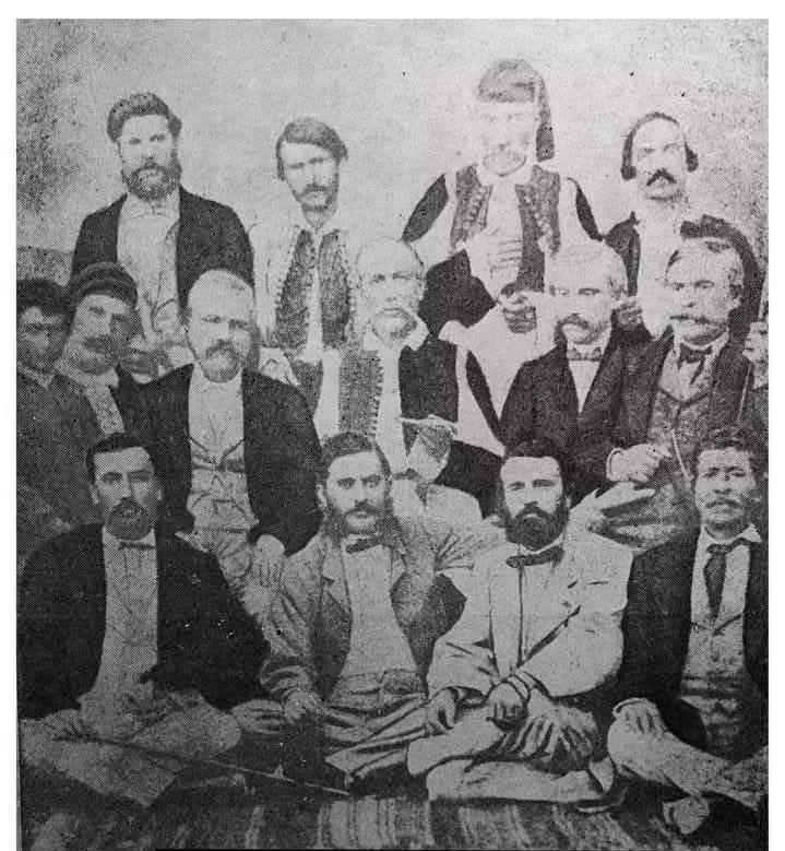
Group photograph of the first settlers of Xylokastro, men in the dress of the period
The first settlers of Xylokastro.Top row, from left: Vellinis, I. Notaras «the wild one» (mayor), Mitropoulos (notary), Polychronopoulos. Middle row, from right: Vasileiou (doctor), Adrianidis (doctor), Monastiriotis, St. Tsirogiannis and Theocharis with his child. Bottom row, from right: Chrysikopoulos, Spyros Notaras (minister), Ioannis Ioannou (lecturer, doctor) and Tampakopoulos.

At a glance

From the Argo to the town of today

Six stages that explain how a mythical harbour ended up being called Xylokastro.

  1. Mythical times

    The Argo, built from Pelion pine, moors on the coast. The harbour takes the name Aristonautai.

  2. Antiquity

    Aristonautai serves as the seaport of Pellene, the easternmost city of the Achaean League.

  3. Frankish years

    The Venetians build a wooden barracks on the hill of Katis. The place becomes Xylokastro.

  4. 1791

    The name XILO CASTRO is officially recorded on a map for the first time.

  5. 19th century

    From ten houses at Ypsila Alonia, Xylokastro becomes a town and the seat of the Municipality of Trikala.

  6. Today

    Pefkias, the pine forest on the shore, is the signature of the town.

See the place up close

The history goes on on the ground

The Cave of Hermes, Trikala and Ziria are forty to sixty minutes from the beach.

Sources: Pausanias 2.12.2 & 7.26.14 · Strabo · Pouqueville, "Travels in Greece" (1814) · V. Vasilopoulos, "Peloponnesian Encyclopaedia" · St. Koutivas · el.wikipedia "Aristonautai" · en.wikipedia "Pellene", "Aristonautae". The section on the name and the first settlers, and the photograph, draw on a text by Thanasis Panou.